Export to MicroStation Elements

Some workflows require the ability to save OpenCities Map features as simple MicroStation elements for use in MicroStation or other applications that do not understand OpenCities Map features. The Export tool can be used to export one or more layers to the MicroStation DGN format. In addition to exporting the graphics, the property data can be exported as MicroStation Item Types when Create Item Types is toggled on.
The Export tool can be selected from the icon bar in the Map Manager or from the right-click context menu of the selected feature or layer group.
To export selected features to MicroStation elements:
- In the Map Manager, select the features to be exported.
- Select the Export tool.
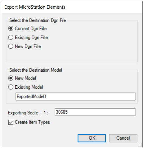
- In the Export MicroStation Elements dialog, set the destination file, destination model, and export scale. The export scale is required since feature symbology may differ based on the view zoom scale. The default scale is the current scale of the active view.
- Turn on Create Item Types if property data should be exported with the graphics.
- Click OK to initialize processing.
To export the entire contents of the open design file to MicroStation elements:
- Select File > Export .
- Choose Geospatial File Types .
- Choose DGN file.
- In the Export MicroStation Elements dialog, set the destination file, destination model, and export scale. The export scale is required since feature symbology may differ based on the view zoom scale. The default scale is the current scale of the active view.
- Turn on Create Item Types if property data should be exported with the graphics.
- Click OK to initialize processing.